Neuwerk
 | |
| Geography | |
|---|---|
| Location | North Sea, Elbe mouth |
| Administration | |
Germany | |
| Demographics | |
| Population | 36 |
Neuwerk (3 km², 36 inhabitants) is a Wadden Sea island on the German North Sea coast. It is located northwest of Cuxhaven, between the Weser and Elbe estuaries. Neuwerk belongs administratively to Hamburg, Germany, in the borough Hamburg-Mitte, even though the distance to Hamburg's center is about 120 km.
During low tide the island can be reached on foot or by horse carriages from Cuxhaven, at other times by ship.
The smaller islands Scharhörn and Nigehörn close to Neuwerk are bird sanctuaries, closed to the public. All three islands and the Wadden Sea around them form the Hamburg Wadden Sea National Park.
History
The oldest existing document that mentions Neuwerk is a Frisian contract of 1316, where its old name Nige O is used.
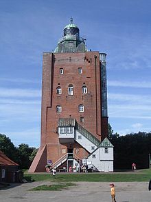
Since the Elbe river was vital to the Hanseatic League's member Hamburg, in 1299 a 35 meter tower was built as lighthouse and protection against pirates. The lighthouse existing today was built between 1367 and 1369 after a fire destroyed the earlier one. It is Hamburg's oldest existing building as well as Hamburg's last fortification.
In the early 20th century, tourism became important for Neuwerk.
Due to the Greater Hamburg Law Neuwerk became part of Prussia in 1937, and thus after World War II it was given to the new state of Lower Saxony. In 1969 Hamburg waived older rights on harbour estate in Cuxhaven in favour of Neuwerk and Scharhörn.[1]
Notes
External links
This Hamburg location article is a stub. You can help Wikipedia by expanding it. |